DRONE SERVICES FOR VANCOUVER CONSTRUCTION COMPANIES
There are so many cost-effective uses for Aerial Drone operations in the construction industry that you really need to find out how we can help.
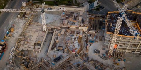
For construction projects, Hawkeye Heli Video can capture high-resolution images (Up to 5K) to create 2D or 3D orthomosaic maps to monitor progress, gather data and showcase completed work. If you need to collect comprehensive data for site planning and modeling, we have a package for you. We offer cost-effective volume calculations and analysis, as well as raw footage and data. Aerial Mapping of a Construction Site allows one to track and follow progress, see elevation changes, take precise measurements (within millimeters) of volume and area, and much more.
Along with specialized software, Hawkeye's mapping drones can easily fly an area of a typical construction site, or property, providing timely, high-resolution maps, images and/or video to follow site conditions while offering significant efficiency gains compared to traditional methods.
Our specialized software can help evaluate site conditions by following elevation changes and taking measurements of stockpiles or volume. Capture reality, gain insights, and make decisions in Real-Time.
Hawkeye is happy to partner with licensed General Contractors, Architectural Firms, Surveyors, and Engineers to provide and supplement the field data, produce contour maps and perform volumetric calculations with our maps. We offer solutions and data you need to make informed decisions and save time and money.

